Tag: Myaing

  • At Least 38 Civilians Killed, 15 Injured and 370 Homes Burned: Evidence of Ground and Aerial Attacks by LIDs 101 and 99 in Myaing and Pauk

    At Least 38 Civilians Killed, 15 Injured and 370 Homes Burned: Evidence of Ground and Aerial Attacks by LIDs 101 and 99 in Myaing and Pauk

    At Least 38 Civilians Killed, 15 Injured and 370 Homes Burned: Evidence of Ground and Aerial Attacks by LIDs 101 and 99 in Myaing and Pauk

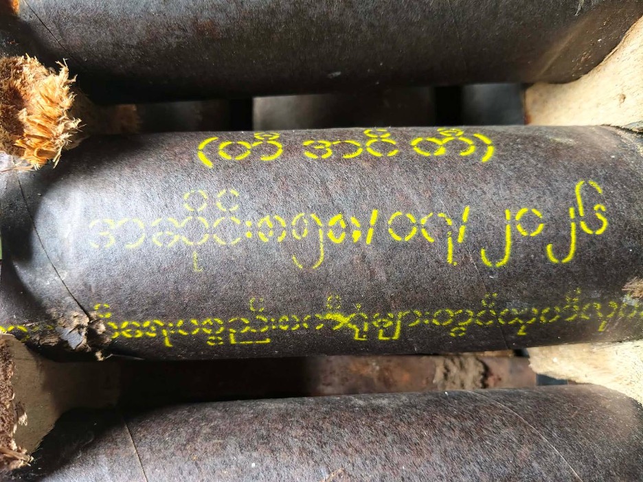
    Weapon remnants found in different locations in Myaing (Source: CAS)

    Highlight

    • At least 38 civilians were killed, including victims in two massacres documented in Htauk Shar Pin village (Pauk Township) and Baw Ton village (Myaing Township).
    • At least 15 civilians were injured in heavy artillery and aerial attacks.
    • At least 370 civilian homes were verified as burned across Myaing Township and neighbouring Htauk Shar Pin village in Pauk Township.
    • Infantry units raided at least 31 villages across Pauk and Myaing Townships, while aerial and heavy artillery attacks affected at least seven additional villages in Myaing Township.
    • LIDs 101 and 99 conducted repeated aerial attacks and heavy artillery shelling against civilian-populated areas, including villages, displacement sites and a monastery.
    • Photographs of military shirts bearing the insignia of both LID 101 and LID 99 corroborated local accounts concerning the units involved in the operation.
    • Evidence from victims’ families, eyewitnesses, aid workers, photographs and weapon remnants indicates patterns of extrajudicial killings, severe ill-treatment, destruction of civilian property and attacks affecting civilian areas.

    Methodology and Evidence Assessment

    This investigation was conducted through a combination of field-based interviews, incident documentation, on-site observations, photographic evidence and cross-checking with local early-warning and flight-spotter information. Our researchers interviewed 11 individuals, including victims’ family members, eyewitnesses, residents, humanitarian and civil society actors and local sources familiar with the movement and activities of the military column. Information collected through interviews was assessed against incident records, photographs, videos, casualty information, property-destruction records and, where available, physical evidence such as remnants of mortar rounds. Our researchers reviewed 117 photos and 11 videos obtained from several sources. The investigation focused on incidents occurring between 23 June and 8 August 2026 in Myaing Township and neighbouring areas of Pauk Township. 

    Timeline of the Incident [23 June – 8 August 2026]

    Date

    Key Events

    23 June 2026

    Magway resistance forces reported engaging and destroying a Myanmar military helicopter near Twin Ma village.

    24 June 2026

    LID 101 and 99 units advanced nearby villages from Twin Ma village. Raided Thar Si and Hnan Si Kan, before reaching Kaing Taw Ma.

    Late June–early July

    Infantry units advanced towards Thin Ma and Gyoke Kone villages.

    13–14 July 2026

    28 civilian homes were burned in Let Khoke Pin village as the military column moved through the area.

    20 July 2026

    Heavy artillery attacks from military positions in Thin Ma affected surrounding villages. Multiple civilian killings were also documented during the military operation, including six victims in Baw Ton.

    21 July–1 August 2026

    65 civilian homes burned in Thin Ma village.

    22 July 2026

    Artillery fire from Thin Ma struck Wet Hpoe, killing civilians and injuring others.

    24 July 2026

    Multiple aerial attacks struck civilian and displacement sites, including Hnan Si Kyin, Gyote Kone and Hnan Sar Kyin.

    24–29 July 2026

    More than 140 aerial attacks were reported over six days, involving fighter aircraft and gyrocopters.

    26 July 2026

    A fighter aircraft attacked So Taw village, Bone Gyi Kan village tract, damaging a monastery and injuring one Buddhist monk and two civilians.

    27 July 2026

    A fighter aircraft attacked Kyet Mauk village. The incident damaged a power line but no civilian casualties were reported.

    31 July 2026

    A fighter aircraft dropped a bomb near Thaphan Kan (Hpan Kan) village. Two gyrocopters subsequently attacked Ma Gyi Kan, damaging civilian homes and injuring cattle. Later that afternoon, another fighter aircraft attacked Ywar Thit Gyi, damaging at least seven houses.

    1 August 2026

    Military forces moving from Thin Ma arrived in Baunt Bin and remained there until the evening.

    2 August 2026

    Military forces reportedly burned civilian homes in Baunt Bin at around 10:00 a.m.

    2 August 2026

    Military forces moved into Yar Gyi Pyin village and remained in the area.

    3 August 2026

    31 civilian homes burned in Kan Net village, Kaing Taw Ma village tract.

    5 August 2026

    Local sources reported that military forces burned homes in Yar Gyi Pyin for the first time during the later phase of their movement through the area.

    6 August 2026

    Local sources reported a second round of house burnings in Yar Gyi Pyin in the morning.

    7–8 August 2026

    Gyrocopters attacks in Su Win killed two civilians and resulted three injuries.

     Background of Myaing Township

    Myaing Township, in northern Magway Region, lies along a strategic security corridor linking central Burma with Chin State, Rakhine State and India. It is also the origin of the Myaing–Pauk–Kamma–Pakokku–Chauk oil belt, which contains several traditional hand-dug oil fields and a major modernised oil and natural gas field.

    Following the 2021 military coup, Myaing became one of the principal contested townships between the junta forces (locally known as Tatmadaw) and pro-democracy resistance forces. Earlier in 2026, resistance forces captured the Pyu-Saw-Htee positions in Wet Poke, Tha Yet Kwa and Tha Yet Kan villages. Currently, resistance groups of the Magway Federal Unit Government controlled most of the township, while Tatmadaw maintained a limited presence through two Pyu-Saw-Htee strongholds and two frontline bases. As the territorial control contracted, Tatmadaw increasingly relied on air power to project military force across Myaing Township, including against oil fields under the control of resistance groups. These operations involved a range of aerial platforms, including fighter aircraft, helicopters, gyrocopters, military-grade paramotors, drones and loitering munitions (kamikaze drones).

    On 23 June 2026, Magway People’s Defence Force released video footage showing its fighters engaging a Tatmadaw helicopter during a military operation, which the group announced resulted in the aircraft being shot down. The incident illustrates the increasingly contested operating environment in Myaing Township.

    Large-Scale Infantry Offensive by LIDs 101 and 99

    On 24 June 2026, a military column comprising troops from Light Infantry Divisions 101 and 99 launched an operation in villages surrounding Twin Ma, where the military-backed Pyu-Saw-Htee militia had maintained a presence since the 2021 coup. Over the following days, the column advanced through a number of villages before reaching Gyoke Kone and Thin Ma, both located near resistance-controlled oil fields in Ba Hin, Wei Taung and Su Win villages along the Myaing–Pauk township boundary.

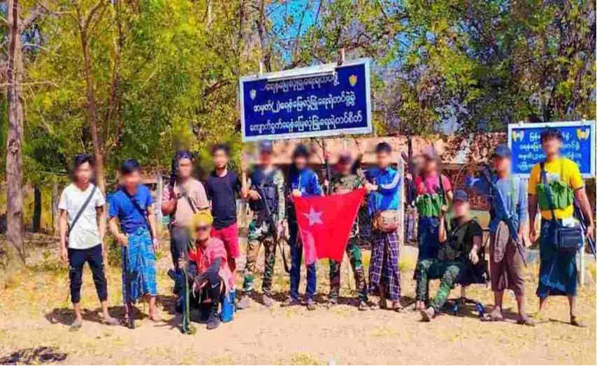
    Our researchers attributed the military operation to forces from LIDs 101 and 99 based on multiple accounts from local sources familiar with the column’s movements and composition. These accounts were corroborated by photographic evidence obtained from the field, including photographs of military shirts bearing the insignia of both LID 101 and LID 99.
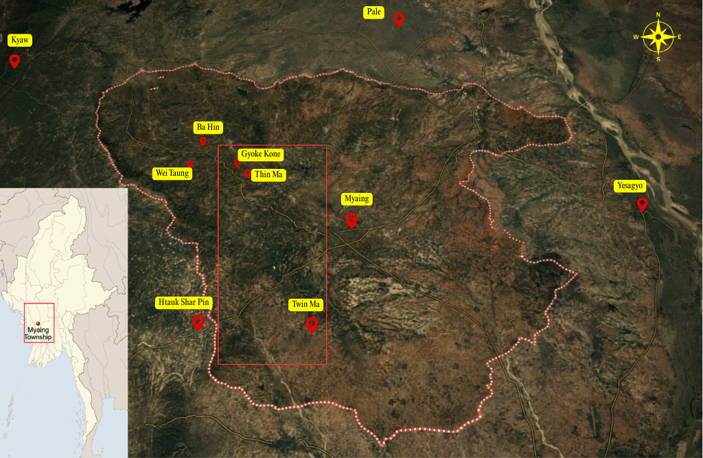
    Operation Area Map of Infantry Raids in Myaing Township (source: CAS)

    Interviews with local resistance sources indicate that the military operation was launched from two staging points – Twin Ma village and the No. 2 Factory in Myaing Township. The sources estimated that the operation involved approximately 1,000 soldiers. Our researchers independently verified that the military column subsequently raided at least 27 villages between 23 June and 2 August 2026. During the period, armed clashes were also reported in several villages, specifically in Hnan Si Kan and Kaing Taw Ma villages. Between 20 and 25 July 2026, junta forces stationed in Thin Ma village repeatedly shelled surrounding villages using 60 mm, 80 mm and 120 mm mortars. The mortar attacks were reported and verified in Baunt Bin, Wet Hpoe, Nyaung Kone (from Ma Gyi Kan village tract), and Kyet Mauk villages. The attacks killed three civilians, injured at least seven others, damaged civilian properties and left unexploded ordnance.
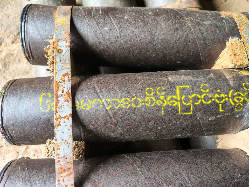
    Mortar rounds documented in Thin Ma village (Photo: private)

    In addition to ground operations, LIDs 101 and 99 extensively employed aerial attacks during the operation, many of which struck civilian-populated areas. Our researchers verified that at least nine villages were subjected to airstrikes involving fighter aircraft and gyrocopters, particularly in areas north of Ba Hin village. The affected villages were Thin Ma, Gyoke Kone, Hnan Sar Kyin, So Taw, Kyet Mauk, Thaphan Kan (Hpan Kan), Ma Gyi Kan and Ywar Thit Gyi. The military column used at least 200 aerial attacks in the last ten days of July, as reported by the Democratic Voice of Burma. Aerial attacks injured at least five civilians, including a Buddhist monk and an elderly woman and caused damage to civilian homes, religious property and other civilian infrastructure across several villages.

    “Which village to burn, which village to burn…”

    Our incident-tracking data documents extensive destruction of civilian homes across several villages during the operation. We verified that LIDs 101 and 99 burned down at least 370 houses across ten villages in Myaing Township and neighbouring Htauk Shar Pin village from Pauk Township. A village-by-village breakdown of the documented destruction is provided below.

    Sr

    Village

    Township

    Number of Houses burnt down

    1

    Htauk Shar Pin

    Pauk

    104

    2

    Thin Ma

    Myaing

    65

    3

    Baunt Bin

    Myaing

    90

    4

    Kan Net

    Myaing

    31

    5

    Let Khoke Pin

    Myaing

    28

    6

    Kaing Taw Ma

    Myaing

    2

    7

    Htan Nge Taw

    Myaing

    4

    8

    Nyaung Kone

    Myaing

    5

    9

    Than Chaung

    Myaing

    5

    10

    Gyoke Kone

    Myaing

    16

    11

    Mya Zee Taw (Zee Taw)

    Myaing

    20

    The destruction occurred repeatedly as the military divisions moved through villages. In Let Khoke Pin, our researchers documented 28 houses burnt between 13 and 14 July. In Thin Ma, 65 houses were recorded as burnt between 21 July and 1 August, while 31 houses were documented in Kan Net on 3 August. The geographical spread and timing of these incidents indicate that the burning of civilian homes accompanied the military divisions’ advance through several villages, as illustrated above. One interviewee described the burning of homes in Let Khoke Pin, Kan Net, Myin Koe Thit and Nyaung Kone,

    “It was not that they only burned particular houses. As the military column moved through the villages, they burned the houses they encountered.”

    The arson attacks also affected places where displaced civilians took shelter. At Mya Zee Taw (Zee Taw) monastery, displaced civilians and monks had taken shelter, while villagers had moved food, seeds and other belongings there because they considered it safer than their homes. The same interviewee said,

    “When the column suddenly arrived, the monks and the displaced people in the monastery had to flee. They ran away with only the clothes they were wearing. The motorbikes, clothes and food supplies that the displaced people had stored at the monastery because they thought it would be safe – all of them were caught up in the burning.”

    The interviewee further stated that food and rice were taken by the soldiers and that two religious buildings and motorbikes were burned. According to a villager who survived the military arrest, the field commander of the military column issued direct instructions to his soldiers about which villages to burn. The source said that the man subsequently escaped from the bunker while the commander was issuing these instructions.

    Despite the escalation of conflict and repeated military raids, villagers in the area had limited access to timely information that could enable them to prepare for or safely evacuate ahead of military advances. The operation also took place amid severe restrictions on civilian communications. In addition to the area-wide internet shutdown, telephone communications were reportedly disrupted as LIDs 101 and 99 entered the area. The disruption of communications severely constrained the ability of local authorities and communities to share early warnings and coordinate civilian evacuations. This largely increased the risk that civilians would encounter the advancing military column. A local resistance source explained,

    “The internet lines on our side were completely cut off, and the telephone lines were also completely cut off. Because of this, the resistance administration could only communicate among themselves as they tried to move civilians away from the military column. Sometimes civilians and resistance forces could no longer make contact and people ended up in different places. They then encountered the military column, and these kinds of things happened.”

    As our researchers observed during the on-site investigation, displaced villagers remain scattered across neighbouring communities and farmland, with extremely limited access to food, shelter and other essential supplies. Among the thousands of people displaced and hundreds of families whose homes have been destroyed, many face a heightened risk of prolonged displacement, having fled with little or no belongings beyond the clothes they were wearing. The displacement has also taken a severe psychological toll on affected communities. One interviewee described the distress experienced by her mother-in-law:

    “My mother-in-law is still very sad. She cannot even speak well over the phone. The more she saw the thick smoke, the more she cried.”
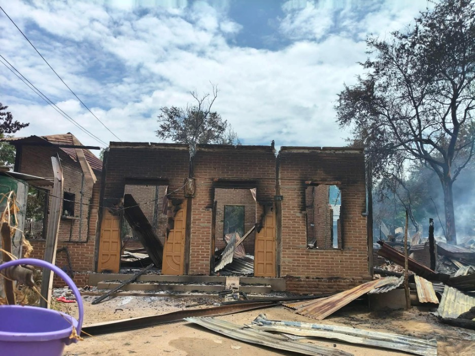
    Houses being burnt down in Thin Ma village, Myaing township on 1 August 2026 (source: CAS)

    Extrajudicial killings: Massacre in Htauk Shar Pin and Baw Ton villages

    Our researchers confirmed that at least 33 civilians were killed during infantry raids by LIDs 101 and 99 between late June and 8 August 2026. Of these, we were able to verify the names, ages, genders, villages of residence and townships of 24 victims, while the remaining victims have not yet been identified. The documented cases include civilians who were reportedly arrested and subsequently killed, subjected to torture and other ill-treatment, shot, or apparently burned alive. 

    The circumstances surrounding several of the killings demonstrate a pattern of capture, detention, severe ill-treatment and subsequent killing, rather than deaths occurring solely as a result of armed clashes. In one case in Htauk Shar Pin village, the victim was captured by soldiers while returning from visiting his sisters. According to his wife, who subsequently received the call to identify his body, he was found the following day with his hands bound behind his back and severe injuries to his genital area. His anus had been cut and mutilated with a knife, and his penis had also been cut. The physical condition of the body, together with the fact that his hands had been bound, provides strong evidence that he was subjected to severe physical abuse before his death.

    The victim’s wife provides a direct explanation of the sequence of events leading to his death. She stated that he was captured by soldiers while returning from visiting his sisters and that the family was subsequently contacted by the village rescue team to identify his body. Through our local sources, we have confirmed that he was taken alive and subsequently found dead in military custody, rather than killed during an armed engagement. The restraints and extensive mutilation documented on his body further demonstrate the severe ill-treatment inflicted upon him before or in connection with his killing.

    The account is further corroborated by a local aid worker whom we interviewed and who participated in recovering the bodies of other victims in the area. The aid worker described two additional victims, both men aged 50 and 63, whose bodies were found naked, with their elbow tendons cut. The worker also reported finding a military knife inserted into the anus of one of the victims. Our researchers reviewed photographs taken at the scene and verified that the bodies were naked and displayed visible signs of severe physical ill-treatment. These accounts reiterated our finding of a recurring pattern of ill-treatment of civilians by the junta forces across central Burma.

    Another massacre was also verified in Baw Ton village of Myaing, where our researcher confirmed six civilian deaths on 20 July 2026. Five victims were identified as men, aged between 23 and 59 while one female victim remained unidentified. A local civil society group we interviewed reported that these villagers were burnt alive, but we couldn’t independently verify it.

    The victims were civilians from the same village, and our evidence does not indicate that their deaths resulted from an armed clash. The Baw Ton incident therefore constitutes a significant case for further investigation into the military column’s treatment of civilians and the broader pattern of extrajudicial killings documented across Myaing Township.

    Table 1: List of the victims who were killed by the military column of LIDs 101 and 99

    Sr

    Name

    Age

    Gender

    Village

    1

    Internal Record

    Unknown

    Male

    Thar Si

    2

    Internal Record

    Unknown

    Male

    Hnan Si Kan

    3

    Internal Record

    Unknown

    Male

    Hnan Si Kan

    4

    Internal Record

    Unknown

    Male

    Meik Hti Lar

    5

    Internal Record

    Unknown

    Male

    Meik Hti Lar

    6

    Internal Record

    Unknown

    Male

    Wet Poke

    7

    Internal Record

    30

    Female

    Htauk Shar Pin

    8

    Internal Record

    48

    Male

    Htauk Shar Pin

    9

    Internal Record

    58

    Male

    Htauk Shar Pin

    10

    Internal Record

    35

    Male

    Htauk Shar Pin

    11

    Internal Record

     75

    Male

    Htauk Shar Pin

    12

    Internal Record

    Unknown

    Unknown

    Htauk Shar Pin

    13

    Internal Record

    50

    Male

    Kan Net

    14

    Internal Record

    63

    Male

    Kan Net

    15

    Internal Record

    70

    Male

    Myin Koe Thit

    16

    Internal Record

    67

    Male

    Kaing Taw Ma

    17

    Internal Record

    31

    Male

    War Yin Chaing

    18

    Internal Record

    45

    Male

    Baunt Bin

    19

    Internal Record

    40

    Male

    Baunt Bin

    20

    Internal Record

    45

    Male

    Baunt Bin

    21

    Internal Record

    Unknown

    Male

    Myin Koe Thit

    22

    Internal Record

    60

    Male

    Kaing Yoe

    23

    Internal Record

    35

    Male

    Kun Lat

    24

    Internal Record

    35

    Male

    Kun Lat

    25

    Internal Record

    68

    Male

    Kun Lat

    26

    Internal Record

    23

    Male

    Kun Lat

    27

    Internal Record

    Unknown

    Female

    Baw Ton

    28

    Internal Record

    40

    Male

    Baw Ton

    29

    Internal Record

    35

    Male

    Baw Ton

    30

    Internal Record

    35

    Male

    Baw Ton

    31

    Internal Record

    59

    Male

    Baw Ton

    32

    Internal Record

    40

    Male

    Baw Ton

    33

    Internal Record

    56

    Male

    Than Chaung

     Aerial Attacks and Heavy Artillery

    The ground offensive by LIDs 101 and 99 was accompanied by repeated aerial attacks and heavy artillery fire. Our evidence indicates that these attacks were not isolated incidents; instead, they are critical elements of a coordinated military operation, during which civilian homes, monasteries, displacement sites and other civilian-populated areas were repeatedly targeted.

    While the infantry raids were concentrated around villages connected to the Tatmadaw’s two frontline positions – Twin Ma Pyu-Saw-Htee post and No. 2 Factory frontline post – the aerial attacks were concentrated in villages farther from the military column’s immediate reach. A closer examination of airstrike incidents in eight villages indicates that LIDs 101 and 99 used aerial attacks to support the advance of their infantry column towards resistance strongholds. As the infantry column advanced from Thin Ma village, aerial attacks were repeatedly reported in neighbouring villages, including Kyet Mauk, Thaphan Kan (Hpan Kan), Ma Gyi Kan and Hnan Sar Kyin. According to our on-site observation, the military column used at least 200 aerial attacks, which caused serious harm to the civilian population in the community. According to local sources we interviewed and early warning information, the attacks involved both gyrocopters and fighter jets operating from different airbases.

    The military column also used 60 mm, 80 mm and 120 mm mortars from positions in Thin Ma village to strike surrounding communities. We reviewed photos of remnants of these weapons, recovered from three locations after the forces left Thin Ma. Some 120 mm mortar remnants bore lot numbers indicating manufacture in 2026 by Myanmar Defence Industries (commonly known as KaPaSa). Unexploded 60 mm mortar rounds were also documented in Ywar Thit Gyi and Baunt Bin on 22 July. 
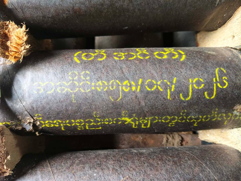
    Weapon remnants found in different locations in Myaing (Source: CAS)

    The artillery attacks caused both immediate and delayed civilian harm. On 22 July, junta forces stationed in Thin Ma fired heavy mortar rounds at Wet Hpoe village, which killed three civilians and injured at least seven others. Two days later, 120 mm mortar rounds were reportedly fired towards other villages, while additional mortar fire continued as the column moved through the area. The use of heavy mortars allowed the military to strike villages beyond its immediate physical presence; however, civilians remained exposed even when the ground column had not entered their communities.

    In the case of Wet Hpoe, we verified that a husband and wife, both over 50, were killed when artillery struck their home. Their 28-year-old daughter, who was seriously injured in the same attack, subsequently died from her injuries. Other members of the family and nearby civilians sustained serious or minor injuries. A local healthcare worker described the victim’s condition on arrival at the clinic:

    “When she arrived at the clinic at 11:00 am, she was already in a critical condition. We could only provide basic emergency care to stop the bleeding and provide fluids. She had severe injuries, heavy blood loss and her chances of survival were considered unlikely. She was later transferred for further treatment but died from her injuries on the same day.”

    A young, displaced person who witnessed the incident described how the family was attempting to flee when the shell struck.

    “They [affected family] went into their village, Wet Hpoe, to get the medicine. When they [soldiers of Tatmadaw] fired artillery toward Wet Hpoe village, they [the villagers] heard the first shell and shouted, ‘It is dangerous, move, move!’ They rushed to get onto the three-wheeled motorbike. If they did not get on, they might not have been hit. But as they were getting onto the vehicle, the artillery shell struck next to their location. Three of them were injured, and later their daughter died.”

    Our casualty records document 15 people injured and 5 killed by aerial and artillery attacks between 22 and 26 July. Seven of the 15 injured were over the age of 50. The victims included displaced people from Thin Ma, Baunt Bin and Khway Mway, as well as civilians sheltering at a monastery in So Taw.

    Table 2: List of casualties due to aerial attacks in Myaing township

    Sr

    Name

    Age

    Gender

    Village

    Remarks

    1

    Internal Record

    50

    Male

    Wet Hpoe

    Death due to artillery attacks.

    2

    Internal Record

    52

    Female

    Wet Hpoe

    Death due to artillery attacks.

    3

    Internal Record

    28

    Female

    Wet Hpoe

    Death due to artillery attacks.

    4

    Internal Record

    39

    Male

    Su Win

    Death due to gyrocopter attacks.

    5

    Internal Record

    32

    Female

    Su Win

    Death due to gyrocopter attacks.

    6

    Internal Record

    52

    Male

    Wet Hpoe

    Injured due to artillery attacks.

    7

    Internal Record

    54

    Female

    Wet Hpoe

    Injured due to artillery attacks.

    8

    Internal Record

    60

    Male

    Wet Hpoe

    Injured due to artillery attacks

    9

    Internal Record

    40

    Male

    Wet Hpoe

    Injured due to artillery attacks

    10

    Internal Record

    51

    Male

    Wet Hpoe

    Injured due to artillery attacks

    11

    Internal Record

    42

    Female

    Wet Hpoe

    Injured due to artillery attacks

    12

    Internal Record

    53

    Female

    Wet Hpoe

    Injured due to artillery attacks

    13

    Internal Record

    30

    Male

    Khway Mway

    A displaced man from Khway Mway village, got Injuries due to gyrocopter attacks in Hnan Sar Kyin on 24 July 2026.

    14

    Internal Record

    60

    Male

    Baunt Bin

    A displaced man from Baunt Bin village, got injuries due to attacks in Han Sar Kyin on 24 July 2026.

    15

    Internal Record

    34

    Male

    So Taw

    Got injuries due to aerial attack against the monastery of So Taw village, on 26 July 2026 by Y-12 of Tada-U airbase.

    16

    Internal Record

    42

    Male

    So Taw

    Injured due to aerial attack against the monastery of So Taw village, on 26 July 2026 by Y-12 of Tada-U airbase.

    17

    Internal Record

    81

    Female

    So Taw

    Injured due to aerial attack against the monastery of So Taw village, on 26 July 2026 by Y-12 of Tada-U airbase.

    18

    Internal Record

    37

    Male

    Su Win

    Injured due to gyrocopter attack.

    19

    Internal Record

    47

    Male

    Su Win

    Injured due to gyrocopter attack.

    20

    Internal Record

    34

    Male

    Su Win

    Injured due to gyrocopter attack.

    Findings and Assessment

    The operation combined ground raids, village burning, extrajudicial killings, heavy artillery and aerial attacks, extending the military’s reach beyond areas directly engaged by infantry forces. While ground forces advanced through villages, artillery positions in Thin Ma repeatedly shelled surrounding communities, while fighter aircraft and gyrocopters struck villages farther from the column’s immediate position. The timing and geographic overlap indicate that aerial and artillery attacks formed an important component of the wider operation.

    The investigation verified at least 38 civilian deaths, including cases involving arrest followed by killing, shooting, severe ill-treatment and alleged burning alive. In several cases, evidence indicates that civilians were taken alive and subsequently found dead. In Htauk Shar Pin, a victim was reportedly captured and found the following day with his hands bound and severe genital injuries. His wife’s testimony was corroborated by an aid worker and photographs showing visible signs of severe physical ill-treatment. The evidence establishes a pattern of capture, detention, severe ill-treatment and subsequent killing, amounting to extrajudicial executions and torture or other cruel, inhuman or degrading treatment.

    Researchers verified the burning of at least 370 civilian homes across Myaing Township and neighbouring Htauk Shar Pin village in Pauk Township. The timing and geographic spread indicate that the destruction accompanied the military column’s advance rather than resulting solely from armed clashes. Witnesses also described soldiers burning homes along their route and destroying property stored at Mya Zee Taw (Zee Taw) monastery, where displaced civilians had sought shelter.

    Aerial and artillery attacks further extended the operation’s reach into civilian areas. Researchers documented fighter aircraft and gyrocopter attacks, alongside 60 mm, 80 mm and 120 mm mortar fire from Thin Ma, affecting villages, displacement sites and a monastery and causing civilian casualties and property damage. Photographs of weapon remnants and information from early-warning and flight-spotter networks corroborated accounts of these attacks. The pattern raises serious concerns regarding compliance with the principles of distinction, proportionality and precautions in attack.

    Accountability and Recommendations

    The evidence warrants further investigation into the responsibility of LIDs 101 and 99 and their commanders for unlawful killings, severe ill-treatment, destruction of civilian property and attacks affecting civilians. Accountability mechanisms should preserve and independently assess available evidence, establish the chain of command and operational responsibility and investigate individual and command responsibility. Domestic and international actors should ensure that survivors and victims’ families have access to truth, justice and effective remedies, including reparations, while protecting witnesses and preserving evidence for future judicial proceedings.
  • Petro-Contestation and Emerging Governance Orders in Magway

    Petro-Contestation and Emerging Governance Orders in Magway

    Petro-Contestation and Emerging Governance Orders in Magway

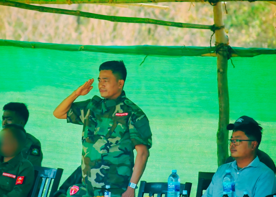
    Bo Let Yar and Ye Htun Zaw attend the closing ceremony of the first cohort training of the Magway Federal Unit Guard Force. (Photo: Mandalay Free Press)

    This situational analysis is produced under Ah Nyar Studies as part of our broader effort to inform developments in central Burma and advance contextual understanding of the region. The analysis examines post-coup dynamics of natural resource control in Magway, with particular attention to the oil industry’s strategic importance to armed actors. It explores how oil fields have become embedded within evolving conflict structures and shaped authority, revenue generation and local governance.

    In addition to an extensive review of secondary sources, the analysis draws on nine key informant interviews with individuals possessing expert knowledge of the subject matter, including senior CDM staff formerly employed in oil fields in central Burma.

    Introduction

     After the 2021 coup, oil fields (locally known as Yae Nan Hmaw or Yae Nan Myay) have become contested strategic assets, where control over production and revenue is increasingly fragmented among the military regime, the NUG and local resistance groups, with significant implications for governance, security and energy access for people. These groups have been heavily contested across Magway, particularly in resource-rich townships.

    As of 2026, local resistance forces in Magway controlled two of the seven oil fields under the union government’s authority. The two major oil fields located in Pakokku, Myaing, and Pauk townships are currently under the management of the resistance administration. Oil and gas from these fields provided supplies for the Refinery Industry in Chauk township through Kamma and Pakokku.

    What do these oil fields and routes mean to resistance groups in Magway? How do these resources define the fate of the resistance movement and governance?

    Active Oil Fields in Magway

     Myanmar’s crude oil production is sourced from both onshore oil fields and offshore oil and natural gas blocks. There are at least ten onshore oil fields across the country, of which seven are in Magway. Major production comes from Yenangyaung, Chauk, Mann Yae Nan Myay, Pyay Yae Nan Myay, Shwepyitha (Myan-aung), and the Myaing–Pauk areas, according to senior officials who worked in the industry and now joined CDM. Among these, the Yenangyaung, Chauk, and Mann Yae Nan Myay in Magway Region are among the oldest in the country and have historically been among the most productive.

    The Htauk Shar Pin Oil field historically referred to the oil-producing area south of Minbu, beginning from Ta Pin village and extending through the areas around Htauk Shar Pin, Kywe Tho Myaung, Shwe Yaung Taung, and Hpa Lan Yone villages. The Kanni Oil field refers to the oil-producing area around Kanni village at the southern edge of Minbu township, including the surrounding areas of Htein Taw and Pike Pin villages. At present, the Htauk Shar Pin and Kanni oil fields in Minbu township, together with the Htan Kaing and Yae Nan Ma oil fields in Minhla township, are collectively referred to as the Htauk Shar Pin–Kanni Oil fields.

    The Sabe–Thagyitaung oil fields are located along the route from Pakokku through Kyun Chaung toward Seikphyu township, forming part of a broader oil belt that stretches across the country’s centre. According to a local source from Myaing township, this petroleum belt extends from Padauk Kone village in Pale Township, Sagaing Region, southward through areas such as Nyaung Ma, Sin Swei, Wei Taung, and Su Win, before continuing toward Thagyitaung and the Si Kaung area near the Bagan River port (of Irrawaddy River).

    Other major oil fields in Magway include Kyauk Khwet and Hpa Lan Kaine in Myaing and Pauk townships, as well as Wei Taung, Suwin, Nyaung-ma, Htan Kaing, Sabe–Thagyitaung, and parts of the broader Pakokku–Myaing–Pauk oil belt. Local sources describe the area stretching along the ASEAN Road between Myaing and Pauk as one of the main concentrations of hand-dug oil wells and small-scale extraction sites. Some areas, particularly Kyauk Khwet from Myaing township and Hpa Lan Kaine from Pauk township, are also known for their relatively high oil output, with local sources describing some wells as producing large volumes of crude oil.

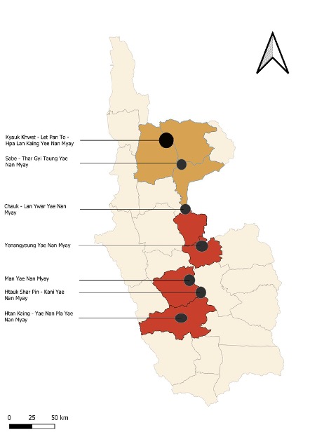
    Seven Oil Fields in Magway. Two in the yellow zones are under the control of resistance groups.

    Unlike smaller hand-dug wells common in other parts of the central dry zone, some deposits in these mountainous areas reportedly require deeper and more mechanised extraction methods. In recent years, however, extraction methods have gradually become more mechanised with the increased use of machinery and technical equipment.

    Traditional Hand-Dug Well or Let Yet Twin

    Apart from the said major onshore oil fields, there are several tiny oil fields spreading across Magway. These are better known as Let Yet Twin, as locals call them. Traditional hand-dug wells in the region can reach depths of thousands of feet, with workers manually drilling, lowering equipment, and extracting crude oil under difficult conditions. According to Magway government records , there were 45 existing shallow hand-dug oil blocks and 11 newly approved blocks operating in Magway Region in the 2016–2017 fiscal year. This expansion continued into the 2017–2018 cycle as authorities approved 20 license extensions and 12 new permits, generating over 1.5 billion kyats for the regional fund in a single year. These figures represent the last phase of formal stability before the sector became contested; by the 2018–2019 fiscal year, the region’s output from seven major oil fields reached over 2.1 million barrels of crude oil, followed by nearly 3.5 billion cubic feet of natural gas in the 2019–2020 period.

    Resistance Control over Oil and Natural Gas Fields in Magway

    Resistance groups have gained control over oil fields and surrounding communities across Myaing, Pauk and Kamma townships, including two major oil fields previously under the authority of the union government. These are Kyauk Khwet–Let Pan To and Hpa Lan Kaing oil fields in Myaing and Pauk townships and Sabe-Thargyitaung oil field in Pakokku township.

    Earthquake People’s Defence Force fighters in front of a security station of Kyauk-Khwet Oil Field (Photo: Earthquake People’s Defence Force)

    According to U Zaw Min, Minister of Planning and Finance in 2020, these oil fields produced not only crude oil but also natural gas prior to the expansion of resistance control. Official data indicates that the annual natural gas production capacity in FY 2019–2020 reached 3,480 million cubic feet across five major oil fields, including the two now under resistance control. Local sources connected to resistance administrations in Myaing and Pauk confirmed the continued extraction of crude oil, but noted technical limitations regarding natural gas production, stating that:

    “We are only capable of producing crude oil from these two fields, but not natural gas due to technical requirements.”

    Magway regional government data further reported that total regional natural gas production capacity reached 4,554 million cubic feet in FY 2017–2018 and 3,739 million cubic feet in 2018–2019. The gas was distributed across Magway and Mandalay Regions to supply state-owned industrial facilities, including cement and cotton factories. Apart from these two major oil fields, resistance forces also control numerous traditional hand-dug oil wells across Magway, particularly in the areas of Myaing, Pauk, Kamma and Pakokku.

    Refinery Industries

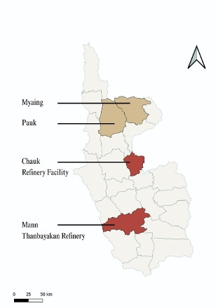
    Magway is a major refinery spot for Myanmar’s petroleum sector. Two of the three major refineries are located in the region. They are;

    • The Petrochemical Complex, locally known as Man Thanbayakan, is located near Minhla Township in Magway Region. The facility was constructed in 1982 by Mitsubishi Heavy Industry with a design refining capacity of 25,000 barrels per stream day (BPSD), and production commenced in 1986. Historically, the complex processed crude oil primarily sourced from the Mann Yae Nan Myay and Htauk Shar Pin–Kanni oil fields. Its products include gasoline, diesel, ATF (aviation turbine fuel), LPG, kerosene, fuel oil (FO) and petroleum coke (pet coke). According to official information, the current operational capacity is approximately 8,500 BPSD (around 300,000 gallons per day), depending on the availability of locally produced crude oil. The facility is also reportedly undergoing upgrading and modernisation works.
    • The (2) Refinery in Chauk Township is one of the oldest refineries in Myanmar. Built in 1954 by the Foster Wheeler Company of England, the refinery consists of an atmospheric distillation tower, a vacuum tower and wax extraction plants, with a design processing capacity of 6,000 barrels per stream day (BPSD). The facility historically processed only locally produced crude oil, primarily sourced from the Chauk and Yenangyaung oil fields, as well as crude oil extracted from the Kyaut Khwet and Lat-pan-to oil fields in Pauk and Myaing townships. Crude oil from the upper part of Magway was transported via pipeline to the Ayadaw Oil field near Tant-Kyi-Taung in Pakokku Township before being sent onward to the refineries in Chauk. In addition to crude oil transportation, natural gas extracted from the Kyaut Khwet field was previously transported by pipeline to Aya-daw and industrial facilities in Wazi to support factory operations. The refinery historically produced gasoline, kerosene, diesel, wax, fuel oil (FO) and blue oil. However, according to official information, the plant was shut down on 5 March 2019 due to the declining availability of local crude oil and natural gas.

    Their combined output accounted for only around 3 per cent of domestic fuel consumption.

    Map Showing Refinery Industries in Magway

    The Recent Deal with the Chinese Corporation for Htauk Shar Pin-Kanni Oil Field

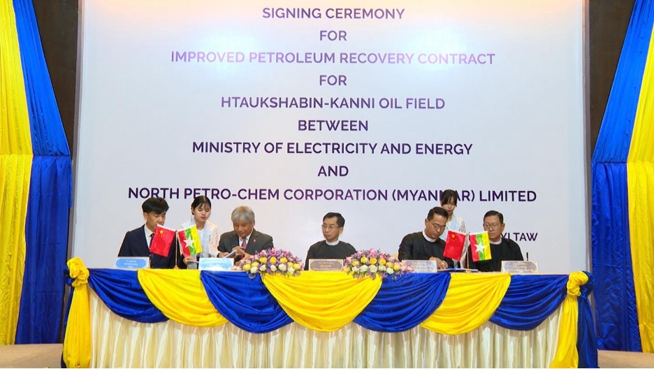
    According to state media reports published on 12 April 2026, the Ministry of Electricity and Energy of the Naypyitaw regime signed an agreement with China-based North Petro-Chem Corporation (Myanmar) to increase crude oil production at the Htauk Shar Pin–Kanni oil field in Minhla township. The company, with its mother corporation in Xi’an, northern China, is closely associated with the Belt and Road Initiative. The company started Myanmar operations in 2011 with its principal activity for the extraction of crude petroleum and natural gas, as stated in Myanmar’s official source. It has been involved in Myanmar’s petroleum sector for more than a decade through exploration and production projects.

    On 10 April 2026, the agreement was reportedly concluded shortly after the formation of the newly formed Naypyitaw regime led by ex-general Min Aung Hlaing. Myanmar state media reported that the initiative aims to boost domestic crude oil production in response to Myanmar’s heavy reliance on imported fuel, which accounts for approximately 97% of national consumption, and to help alleviate ongoing fuel shortages. The details of the agreement remain unknown.

    Signing Ceremony for Hautkshabin-Kanni oil field between the Chinese Company and MOGE (Photo: Global New Lights of Myanmar)

    Under the evolving landscape of natural resources politics in Central Burma, four key issues emerge that shape how oil fields are contested, governed, and integrated into the broader conflict economy.

    1) How is the conflict economy structured around oil fields?

    The conflict is increasingly shaped by a fragmented and adaptive political economy rather than fixed territorial control. Since the 2021 coup, oil-producing areas such as Htauk Shar Pin–Kanni and the Myaing–Pauk fields have become contested economic nodes where authority over extraction, transport, and taxation is dispersed among the military, resistance structures, and local actors. While formal ownership often remains with state-linked institutions, actual control on the ground is fluid and continuously negotiated.

    In particular, mature fields like Htauk Shar Pin–Kanni, where most reserves have already been exploited and production is technologically constrained, retain strategic value not because of untapped resources, but because of their integration into wider supply chains and refining systems, including the Mann Thanbayarkan refinery. Within this system, brokers and traders play a critical but less visible role by facilitating the movement of crude oil, refined fuel, and essential goods across conflict lines. These intermediaries operate through highly flexible arrangements, often engaging with multiple armed actors simultaneously and shifting allegiances based on access, security guarantees, and profit margins. As a result, the conflict economy is sustained not only by armed actors but by a network of commercial agents who mediate flows of fuel, taxation, and information.

    2) How are local armed actors competing over oil fields?

    Myaing and Pauk townships have been resistance stronghold areas since 2021. Several local resistance groups exist alongside the NUG’s 3P-forces and LID 101 of Tatmadaw. Some of them are Ah Nyar Myay Alliance (အညာမြေတပ်ပေါင်းစု), Myaing Villages Revolution Front, Earthquake People’s Defence Force  and Myaing Solidarity Alliance (မြိုင်ညီညွတ်ရေးတပ်ပေါင်းစု), Ghost Of Enemies-GOE Revolution and Southern Yesagyo PDF. The competition among armed actors is structured around control of infrastructure rather than the oil wells themselves. Local resistance forces, including the “3Ps” (people’s defence, administration, and security teams), have consolidated influence by embedding themselves within the oil economy—taxing extraction, regulating access to drilling sites, and controlling key transit routes. For instance, these routes are particularly important, as crude and semi-refined oil must pass through checkpoints linking Pauk–Myaing to Pakokku, Monywa, Mandalay, and beyond. Control over these corridors allows actors to extract revenue at multiple points, creating layered taxation systems that can favour one side or another depending on local arrangements.

    At the same time, Tatmadaw continued to rely on fixed checkpoints and garrison-based control, particularly along major transport axes, requiring goods from certain areas to be channelled through junta-controlled routes. However, the system is not purely adversarial. In practice, there are negotiated flows of commodities—such as rice, fuel, and basic goods—where both sides tolerate or facilitate movement that sustains local economies. This produces a form of transactional coexistence, where economic interdependence tempers military confrontation. Nevertheless, the strategic objective for Tatmadaw remains clear: to regain control over oil-producing zones like Pauk in order to cut resistance revenue streams and re-establish centralized control over fuel distribution, through its continuous raids and aerial attacks.

    3) How do external and allied actors fit into this system?

     China’s involvement is primarily anchored in long-term investments and infrastructure, including pipeline corridors and pre-existing production agreements, some of which date back to before 2015 with contract durations spanning 30–50 years. Recent agreements to increase production at fields such as Htauk Shar Pin–Kanni likely suggest continued interest in maintaining output despite the field’s age and technical limitations. The potential reasons could be seen as to

    First, they may have broader strategic and resource interests in the area beyond oil production, including the potential for coal extraction in central Myanmar. For instance, strategic oil and gas pipeline routes pass through areas such as Ngape, Minbu, and Yenangyaung, while coal-related projects and extraction sites have also been linked to areas around Ngape, Padan, and Minbu. According to local sources, several of these projects are owned, operated, or backed by Chinese-linked companies and investors.

    Second, many Chinese companies had already entered Myanmar’s oil and gas sector long before the 2021 coup through long-term exploration and production agreements. Third, as many Western and foreign companies withdrew from Myanmar after the coup, competition in the sector weakened significantly. This created opportunities for Chinese companies to secure market access, expand their influence, negotiate favorable terms, and establish a stronger foothold in Myanmar’s energy sector with fewer competitors.

    Meanwhile, the role of the Arakan Army (AA) appears to operate through logistical and commercial linkages. For instance, fuel produced in Myaing–Pauk is reportedly refined into usable forms and transported toward Chin and Rakhine areas, where it supports both civilian and military needs. Within this system, brokers and trading networks potentially serve as intermediaries connecting Central Burma’s oil economy to AA-aligned supply chains, reflecting a pattern of alliance-based resource sharing. At the same time, constraints on arms purchase and financing among resistance groups may increase reliance on such resource-based networks. As a result, Magway’s oil fields are not isolated assets but form part of a wider, interconnected conflict economy that links production zones in Magway to operational theatres in Chin and Rakhine which reinforces the strategic significance of even declining oil fields.

     4) Tensions in Myaing and Pauk Townships

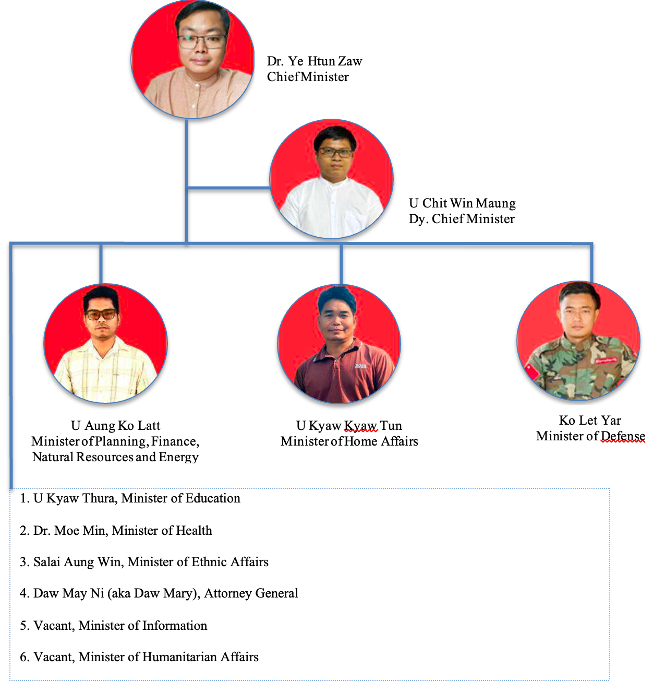
    Magway Federal Unit is a recently emerged political unit within the Spring Revolution, shaped through the interim constitutional arrangement that recognises the National Unity Government of Myanmar as the union/federal government. The arrangement establishes three branches of power: legislative, executive and judicial. NLD lawmaker Ye Htun Zaw, elected from Constituency No. 2 of Min Hla Township, serves as the Chief Minister of the newly formed government, while youth activist Chit Win Maung serves as his deputy, representing the bloc of unions, women’s organisations, youth organisations and people’s strike committees from the Spring Revolution.

    Magway Federal Unit Government (2026)

    Magway has emerged as a unit within the evolving federal model, with the authority to establish armed forces at the level of a state guard. Article 114 of the constitutional arrangement provides that:

    “The Magway Federal Unit Government shall, in consultation with the National Unity Government of Myanmar, establish the following armed forces for defence and security purposes: (a) the Magway Federal Unit Guard Force; and (b) the Magway Federal Unit Security Force / Police Force.”

    In practice, however, the situation is far more complex than it may appear, given the fragmented landscape of armed resistance groups across Magway, despite their shared objective of resisting the military junta. Within Magway’s political geography, numerous small resistance factions, commonly known as Local People’s Defence Forces (LPDFs), operate independently across villages. Alongside them are the National Unity Government’s People’s Defence Forces (PDFs) and People’s Security Teams (PSTs), more widely known as Pa Ka Pha, active across several townships in Magway. The region is also home to ethnic minority communities and their respective armed organisations.

    These include the Yaw, Taung Thar and Asho Chin ethnic groups. The Yaw and Taung Thar communities are indigenous populations inhabiting the Pon Taung and Pon Nyar hill tracts in north-western Magway. In these hilly areas, the Yaw Army and the Yaw Defence Force are the predominant local armed groups. Both identify themselves as Ethnic Armed Organisations/Revolutionary Organisations (EAOs/EROs) and advocate for self-determination in the region. At the same time, major battalions and PSTs (Pa Ka Pha) under the Ministry of Defence of the NUG are active across the three townships of Gangaw, Tilin and Saw.

    The Asho Chin (also known as Plains Chin) are a small ethnic subgroup of the broader Chin ethnic population inhabiting lowland areas of Myanmar, particularly in western Magway. Following the military coup, two major armed groups emerged within the community: the Asho Chin Defence Force (ACDF) and the Chin Defence Force–Asho (CDF-Asho). Both maintain connections with resistance forces operating in the hilly areas of Ngape and Sidoktaya townships along the Magway–Rakhine border. Both groups advocate for ethnic liberation and self-determination.

    These local armed groups have been substantially integrated into the political processes of drafting of the Magway interim constitutional arrangement and formation of the Magway Federal Unit Government. They constitute two of the seven representative blocs shaping the political process and institutional development of the Magway Federal Unit.

    Beyond these two ethnic armed branches, several other LPDFs continue to operate alongside the NUG’s PDFs and PSTs. These include groups such as the People’s Revolution Alliance (Magway), the Southern Yesagyo PDF and the United States of Burma Army-USBA. While some maintain affiliations with the NUG, others operate independently outside the formal NUG command structure.

    Within this fragmented security landscape, security governance in Magway remains inherently challenging, beyond the influence of the NUG alone. The petroleum sites in the resistance strongholds of Myaing and Pauk Townships have constituted particularly intense contestation among the various security actors operating in Magway. More recently, following the formation of the Magway Federal Unit Government and its attempt to establish a Unit Guard Force, Chief Minister Ye Htun Zaw and Security Minister Let Yar attended the closing ceremony of the first cohort of Guard Force training. The event subsequently sparked existing complexities and tensions within the regional dynamics between LPDFs, the NUG and the Magway Federal Unit.

    Bo Let Yar and Ye Htun Zaw attend the closing ceremony of the first cohort training of the Magway Federal Unit Guard Force. (Photo: Mandalay Free Press)

    The NUG reportedly mobilised hundreds of PDF personnel to the area amid claims that the operation aimed to capture Bo Let Yar. However, Soe Thura Zaw, a senior official from the Ministry of Defence, denied the accusation, stating that the situation was not a dispute between the Magway Federal Unit and the NUG. He further rejected claims that the operation concerned control over petroleum sites. According to him, the operation had two primary objectives: (1) to undertake corrective and chain of command measures in response to issues relating to the Myaing PST, following unsuccessful attempts to impose administrative action in 2024 and 2025; and (2) to deploy forces for security duties to protect petroleum sites placed under union/federal management. In response to Soe Thura Zaw’s statement, Chief Minister Ye Htun Zaw wrote on his Facebook that the conflict was associated with resource governance. He further stated that senior NUG officials needed to adhere to the decisions jointly agreed upon between the NUG and the Magway Federal Unit on 5 April 2026 regarding the management of petroleum and related products. Coinciding with the timing of the incident, 42 local PDFs operating in the area and across Magway issued a statement on 18 April 2026 declaring that the groups would affiliate with the Magway Federal Unit under its military command structure.

    Adding to this contestation, Tatmadaw’s LID 101, based in Pakokku and backed by Meiktila-based LID 99, launched a large-scale mobilisation of troops along the main roads connecting Pakokku to Pauk, Myaing and Yesagyo. This triggered the most recent escalation of conflict from late April through to the time of writing of this briefing paper. Thousands of villagers from the three townships have reportedly fled to farmlands and neighbouring villages. More recently, junta forces raided and burned houses in several villages in Yesagyo Township.

    The recently adopted constitutional arrangement of the Magway Federal Unit establishes a policy framework for the sharing of revenues and financial interests between the NUG and the Unit (Section 129), while the Unit retains legislative authority over natural resources (Section 169(d)).

    Conclusion

    Three major contested zones can be observed within Magway’s resistance landscape:

    • The eastern bank of the Ayeyarwady River, particularly the Salay-Chauk-Gwaycho plain;
    • The upland areas on the western bank of the Ayeyarwady River, particularly Minhla, Ngape, Sidoktaya, Mindon and Thayet townships;
    • The Bhan-Kywe and Pa-Khan plains (In Burmese: ဗန့်ကျီ-ပခန်းလွင်ပြင်) (Yesagyo, Myaing, Pale and Yinmarbin townships) and the Pon Taung-Pon Nyar Hills.

    Key Takeaways

    • Security and political contestation are likely to intensify further in resource-concentrated zones and key transportation corridors. These dynamics will involve not only confrontation between the Tatmadaw and resistance forces but also growing competition between the Magway Federal Unit and the NUG.
    • The petroleum agreement between the Chinese company and the Naypyitaw regime represents a development that warrants close attention. It may be understood as more than merely technical assistance from China for petroleum production, carrying potentially significant implications for regional security and political dynamics.
    • The ways the NUG and the Magway Federal Unit manage disputes concerning the administration of petroleum fields in the Myaing-Pauk area will test the integrity of the Magway Federal Unit’s political arrangement. At the same time, the case presents an important point of reference for other emerging federal units and states in Burma.
    • The influence exercised by Arakan and Chin revolutionary organisations, operating within broader alliance frameworks, over Magway’s petroleum fields and strategic transportation routes has become a significant factor shaping the region’s security and political developments. In particular, the security and political positioning of revolutionary forces operating in the Pon Taung-Pon Nyar Hills and the Arakan Yoma hill tracts – areas aligned with the Arakan Army – are becoming critical determinants in Magway’s evolving conflict and political landscape.

    Cite this article: Centre for Ah Nyar Studies. (2026, May 15). Petro-Contestation and Emerging Governance Orders in Magway [Situational Brief]. Centre for Ah Nyar Studies.


en_GBEnglish